


Oct. 18, 5: PM HURRICANE ANA UPDATE
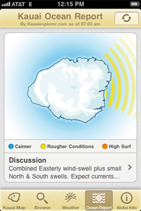
Hurricane Ana continues to move toward the northwest at around 8 mph. The center of Ana is presently located about 145 miles to the south of Lihue. The track of Ana has shifted a bit to the north. The winds along its northern periphery will likely brush by Niihau and Kauai. Thus a tropical storm warning has been issued for those islands. A tropical storm watch remains in effect for Oahu.
A flash flood watch remains in effect for the Big Island until 6 am Sunday and for the remainder of the state through 6 pm Sunday. Locally heavy rainfall and possible thunderstorms are expected as radar shows a large area of showers moving up from the south and southeast toward the smaller islands with heavy rain continuing to move into the Big Island from the southeast.
Strong winds continue to blow over the Big Island summits. Thus the wind advisory has been extended through tonight. Winds over the summits are expected to gradually subside later tonight and Sunday. Meanwhile, the pressure gradient between high pressure located N of area and hurricane Ana, will allow for locally stronger winds to blow over Kauai and Oahu through Sun.
For early next week, as Ana moves W and NW of the area winds will gradually swing around to the SE with a general drying trend and increasingly stable conditions expected across the area.
Category : Blog