
LATEST HURRICANE INFO FROM ACCUWEATHER
Hawaii will still face some hazards this weekend despite the likelihood of escaping a direct hit by Ana.
As of Thursday morning, local time, Ana was a tropical storm and moving westward over the central Pacific.
According to AccuWeather Hurricane Expert Dan Kottlowski, “We expect some strengthening of Ana through Friday, local time, which can bring the system to a Category 1 hurricane.”
Ana will continue on that track through Thursday before taking a turn more to the northwest Friday and through this weekend.
The AccuWeather.com Hurricane Center expects that turn to be gradual with an area of high pressure preventing the hurricane from curving onto or through the islands.
“A minimal system such as a tropical storm, is more likely to take a path more to the west, and south of the islands, while a strong system, such as a major hurricane, is more likely to turn northward,” Kottlowski said.
A track more to the west would keep the strongest and most destructive winds offshore. The same cannot be said for other impacts, which will spread across Hawaii in an east-to-west fashion late Friday through Sunday.
The Big Island, mainly southern areas, and Kauai are at greatest risk of experiencing flooding rainfall and tropical storm-force winds. Such winds could cause tree damage and power outages, while isolated mudslides may result.
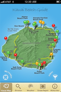
NOTE: Our team at #Kauai Beach Guide iPhone app (FREE this month) will keep updating this post. The Central Pacific Hurricane center is calling for Kauai to get the storm on Monday. Because of the rain and winds, be prepared (see previous blog).
Category : Blog